


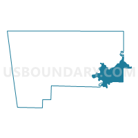
Voting District 084, Benton County, Arkansas
About
Outline

Summary
| Unique Area Identifier | 525933 |
| Name | Voting District 084 |
| County | Benton County |
| State | Arkansas |
| Area (square miles) | 60.25 |
| Land Area (square miles) | 53.56 |
| Water Area (square miles) | 6.68 |
| % of Land Area | 88.91 |
| % of Water Area | 11.09 |
| Latitude of the Internal Point | 36.28191330 |
| Longtitude of the Internal Point | -93.93038060 |
Maps

Graphs
Select a template below for downloading or customizing gragh for Voting District 084, Benton County, Arkansas


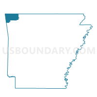
Neighbors
Neighoring Voting District (by Name) Neighboring Voting District on the Map
- Voting District 073, Benton County, AR
- Voting District 077, Benton County, AR
- Voting District 080, Benton County, AR
- Voting District 081, Benton County, AR
- Voting District 083, Benton County, AR
- Voting District 085, Benton County, AR
- BRUSH CREEK Voting District, Washington County, AR
- California Voting District, Madison County, AR
- Johnson Springs Voting District, Carroll County, AR
- Packard Springs Voting District, Carroll County, AR
Top 10 Neighboring County Subdivision (by Population) Neighboring County Subdivision on the Map
- Township 2, Benton County, AR (14,279)
- Township 1, Benton County, AR (13,223)
- Brush Creek township, Washington County, AR (2,877)
- California township, Madison County, AR (1,303)
- Packard Springs township, Carroll County, AR (735)
Top 10 Neighboring Unified School District (by Population) Neighboring Unified School District on the Map
- Springdale School District, AR (90,624)
- Rogers Public Schools, AR (81,256)
- Huntsville School District, AR (14,572)
- Eureka Springs School District, AR (7,998)
Top 10 Neighboring State Legislative District Lower Chamber (by Population) Neighboring State Legislative District Lower Chamber on the Map
- State House District 89, AR (35,559)
- State House District 95, AR (33,192)
- State House District 91, AR (29,747)
- State House District 90, AR (29,000)
Top 10 Neighboring State Legislative District Upper Chamber (by Population) Neighboring State Legislative District Upper Chamber on the Map
- State Senate District 8, AR (105,195)
- State Senate District 35, AR (102,238)
- State Senate District 2, AR (83,273)
Top 10 Neighboring 111th Congressional District (by Population) Neighboring 111th Congressional District on the Map
Top 10 Neighboring Census Tract (by Population) Neighboring Census Tract on the Map
- Census Tract 9502, Carroll County, AR (5,994)
- Census Tract 214.08, Benton County, AR (4,955)
- Census Tract 214.07, Benton County, AR (4,340)
- Census Tract 101.01, Washington County, AR (4,002)
- Census Tract 9601, Madison County, AR (3,878)
- Census Tract 214.09, Benton County, AR (2,468)
- Census Tract 214.05, Benton County, AR (2,035)
Top 10 Neighboring 5-Digit ZIP Code Tabulation Area (by Population) Neighboring 5-Digit ZIP Code Tabulation Area on the Map
- 72764, AR (50,230)
- 72756, AR (38,455)
- 72758, AR (33,487)
- 72745, AR (11,376)
- 72732, AR (4,716)
- 72632, AR (4,449)
- 72738, AR (2,419)